C-MAP Boating
- 4.1
- Rating
- 1.00M
- Installs
- Free
- Price
 Analysis by App-foxy
Choosing a navigation app for a boat is different from choosing one for a car. A road app can usually recalculate after a missed turn; on the water, the important question is whether the chart is useful before leaving shore, remains available when coverage changes, and fits the way you actually plan a trip. I spent time looking at C-MAP Boating with that decision in mind, rather than treating it as just another map app. My overall impression is that it is most appealing to recreational boaters and sailors who want chart-based planning on a phone or tablet without immediately committing to a dedicated chartplotter.
C-MAP Boating is a free Maps & Navigation app from Navico Norway AS, with optional in-app purchases ranging from $0.99 to $99.99 per item. It is rated for Everyone, runs on devices using OS 10 or later, and its current version is 4.6.0. The app has passed the million-install mark and holds a 4.1 average from around sixteen thousand ratings, which suggests a substantial user base but also leaves room for individual experiences to vary.
What I would check before choosing a boating app
My first decision criterion is not the number of buttons on the screen. It is whether the app supports the kind of trip I take. A person who spends an afternoon close to a familiar marina has different needs from someone planning a longer sailing route through unfamiliar waters. C-MAP Boating makes the most sense when marine charts and offline access are central to the decision, not when the main requirement is a general-purpose location finder.
You May Also Like

 Blood Strike: 2.5 Anniversary
Blood Strike’s Loadouts Turn Every Drop Into a Tactical Gamble
A close look at Blood Strike’s custom loadouts: how fast access to signature weapons reshapes its battle royale rhythm, rewards preparation, and narrows the gap between fights.

 Pandora - Music & Podcasts
Pandora’s Music Is Easy to Start, but Harder to Recover
Pandora’s strength is its low-effort path from a seed to a station. Its weak spot is how much confidence it asks you to place in connection, setup, and quiet recovery.

 8 Ball Pool
 Is Built on Rivalries, Rematches, and Routine
A close look at the rivalries, rematches, shared routines, and unanswered safety questions that turn a quick pool match into a persistent mobile community.

 Samsung Music
’s Quiet Strength Is Playing What You Already Own
Its reach comes less from spectacle than from dependable access to a personal library. That simplicity is both the app’s strongest retention engine and its ceiling.

 AccuWeather: Weather Radar
AccuWeather Review: A Quick, Clear Forecast for Everyday Decisions
For everyday plans, the best forecast is the one you can understand quickly. AccuWeather makes rain timing, radar, and local conditions easy to act on, with a few trade-offs.

 Hill Climb Racing
Why Hill Climb Racing Still Turns Crashes Into One More Run
A tiny car, a bumpy hill and one more upgrade: Hill Climb Racing keeps resurfacing because its simple chaos makes every near-miss feel personal.
More From Our News Desk



Offline use deserves special attention. Before heading out, I would open the areas I expect to visit, allow the chart information to finish loading, and then test the device with connectivity disabled. That small preparation step is more valuable than assuming that a map visible at home will automatically remain available offshore. It also gives me a chance to check storage space, battery level, and screen readability before the trip becomes time-sensitive.
I would also decide whether I need planning or active navigation. A chart app can be excellent for examining a route, checking the shape of a bay, and preparing a day on the water, while still being less convenient than a dedicated marine display for constant helm-side monitoring. C-MAP Boating is therefore easier to recommend as part of a sensible setup than as the only instrument a skipper relies on in every situation.
The payment model is another practical consideration. The app itself is free to install, but some capabilities are connected to in-app purchases. I would begin by installing it and exploring the available chart coverage for my usual waters before paying for anything. That approach avoids buying an option that sounds useful in theory but does not match the region, boat, or type of trip I actually have in mind.
How the chart-first approach feels in practice
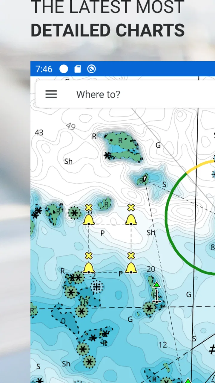
The central benefit is that the app treats boating as a marine-navigation task rather than forcing a road-map mindset onto the water. Coastlines, channels, coves, and open-water passages are easier to consider when the interface is built around nautical charts. For me, that changes the planning conversation: instead of asking only where a pin is located, I can think about how a route relates to the surrounding water and the places I may want to reach.
A realistic example would be a weekend outing from a busy harbor. Before launching, I could study the route to a quieter anchorage, save the relevant chart area for offline use, and review the return path while I still have time and daylight. If weather or fatigue changes the plan, having the broader area prepared is more helpful than downloading only the exact line between two points. The app becomes a preparation tool, not merely something opened after a problem appears.
That workflow also helps when several people share responsibility. One person can handle the helm while another checks the planned route on the phone, or a boat owner can prepare an itinerary before handing the device to a less experienced passenger. I would still treat every chart display as support for judgment, not as permission to ignore local conditions, visibility, seamanship, or the information available on board.
Where C-MAP Boating wins
The strongest case for this app is the combination of marine charting and offline map access in a portable format. A phone or tablet is easier to carry between boats than a permanently installed system, and it can be useful to someone who owns a small craft, rents different boats, or is still deciding whether a larger navigation setup is justified. The free entry point makes it straightforward to evaluate that workflow before spending money.
It is also a good fit for planning away from the helm. I like the idea of sitting at home, looking over a proposed trip, and thinking through alternatives before the boat is moving. That is where a larger mobile screen can be particularly comfortable: I can zoom out to understand the whole outing, then examine the narrower areas that matter. The app’s value is not limited to the moment when I need to know where I am; it begins when I start deciding where I want to go.
Another advantage is flexibility across boating styles. A casual motorboat user may want a simple way to prepare a route, while a sailor may value the ability to inspect a wider area and keep information available when an internet connection is unreliable. Those users do not need identical workflows, and a chartplotter-style app can serve both better than an ordinary street-navigation application.
For a newcomer, the app can also make the transition into marine chart reading less intimidating. I would not call it a substitute for learning navigation, but it gives a practical place to connect a planned journey with the shape of the water. The most useful habit is to zoom out before zooming in: first understand the entire route and possible exits, then inspect the immediate section. That reduces the risk of focusing so closely on a destination that the wider trip becomes an afterthought.
Three habits that make the app more useful
First, I would prepare a route and a fallback route rather than a single ideal line. A boating plan can change because of comfort, traffic, daylight, or a last-minute decision to return early. Having the surrounding chart area ready means I am not starting from zero when the original plan no longer feels right. This is a simple but important distinction between using the app as a live pointer and using it as a planning companion.
Second, I would use the app on the device that is easiest to read without creating a new distraction. A tablet may be better for planning at home, while a phone may be more convenient to carry. Neither choice removes the need to protect the device from water, keep it charged, and position it where it can be checked without taking attention away from the boat. The best screen is the one that supports the crew rather than competing with the person in charge.
Third, I would make an offline check part of the departure routine. I would load the intended region, switch off connectivity, move around the chart, and confirm that the areas I expect to need are still accessible. This is a more reliable test than simply seeing a chart appear while connected to a strong home network. It also exposes practical problems early, when there is still time to change the plan or prepare another device.
These habits reveal a useful trade-off. Offline charts can make the app more dependable when a connection is poor, but they also create a preparation obligation. A user who never plans ahead may find the feature less reassuring than expected. In my view, that is not a flaw unique to this app; it is the cost of wanting marine information available beyond dependable mobile coverage.
Where the experience can become less comfortable
A phone remains a phone, even when it displays a marine chart. Bright sunlight, glare, wet fingers, limited battery, and a small screen can all make detailed navigation less comfortable than it appears indoors. I would be especially cautious about treating the app as the sole source of information on a demanding trip. For a short recreational outing, it may be perfectly practical; for more serious navigation, a dedicated marine display and established onboard procedures may be the better foundation.
The free installation can also create an expectation that everything needed will be included immediately. Because optional purchases are part of the experience, I would inspect the available choices before building a trip around a particular capability. The sensible way to approach the app is as a low-risk starting point with a paid path for users whose needs grow, not as a promise that every boating requirement is covered at no cost.
I would not choose it simply because it has a large install base or a solid average rating. Those figures tell me that many people have tried it, but they do not decide whether it suits my waters, my device, or my experience level. The important test is whether the chart workflow feels clear enough for me to prepare safely and whether the device behaves reliably in the conditions where I intend to use it.
When a different category may fit better
The usual alternative is a dedicated chartplotter. That type of equipment is more natural for a boat that already has a permanent helm station, a power supply, and a crew that wants navigation integrated into the vessel rather than carried in a pocket. If I were outfitting a boat for frequent or demanding use, I would compare the convenience of C-MAP Boating with the visibility, mounting, and onboard integration offered by dedicated hardware. The app is easier to start with, but hardware can be the more appropriate long-term center of navigation.
A general road-map app is a different category altogether. It may be useful for reaching the marina by car, finding a fuel stop on land, or sharing a meeting location with someone who is not on the boat. I would not use it as my primary marine planning tool simply because its familiar interface is convenient. Road maps are designed around streets and land travel, while C-MAP Boating is aimed at the water, where the surrounding chart context matters.
Some boaters may prefer a specialized navigation system already installed on their vessel. That choice can be better when the operator wants one consistent interface, a larger fixed display, and fewer concerns about carrying or charging a mobile device. In that case, the app can still have value for planning away from the boat, but it may not be the main navigation solution.
The app is also not the obvious choice for someone who only wants a simple location-sharing tool. If the goal is telling friends where to meet on shore, checking a road journey, or finding restaurants near a marina, a general mapping service may feel faster and less demanding. C-MAP Boating earns its place when the user wants the marine chart perspective, not merely a moving dot on a familiar map.
The real cost of switching
Switching to a chart app is not only a question of downloading it. I would need to learn how its chart view communicates information, decide how much of my usual boating area to prepare offline, and establish a routine for charging and protecting the device. If I already know a dedicated system well, moving the entire workflow to a phone could introduce more uncertainty than convenience.
There is also a human cost. Everyone on board should know where the device is kept, how to bring up the planned area, and what to do if the battery or screen becomes unusable. A navigation tool is more valuable when the crew can support its use, so I would spend time practicing before a trip rather than making the first serious test in unfamiliar water.
For someone moving from a paper chart, the adjustment is different. The app offers portability and a live digital view, but it can encourage excessive zooming or dependence on the screen. I would keep the habit of looking at the whole route and considering alternatives, rather than following a narrow display without understanding the surrounding area. Digital convenience should improve preparation, not replace it.
The financial side is relatively approachable because the app is free to start. Still, optional purchases mean I would treat the first outing as an evaluation period. I would check whether the available chart experience supports my normal destinations, whether offline preparation fits my routine, and whether the device remains comfortable to use outdoors. Only after those checks would I consider paying for additional functionality.
My recommendation for different boaters
I recommend C-MAP Boating to recreational boaters, sailors who want a portable planning aid, and owners who are not ready to install or depend on a dedicated chartplotter. It is especially attractive if offline marine maps are important and if you are willing to prepare before leaving shore. The free starting point makes it easy to see whether the chart-based workflow feels natural on your own device and in the waters you know.
I would be more cautious about recommending it as the only navigation resource for demanding passages, poor visibility, or situations where a phone’s battery, screen, or mounting position could become a serious weakness. In those cases, a dedicated system or a broader onboard setup may be a better primary choice, with the app serving as a secondary planning tool. That is not a criticism of its purpose; it is a reminder that portable software and permanent marine equipment solve different problems.
Before a first trip, I would install it, examine the chart area around my usual launch point, prepare the likely route plus an alternative, and test the offline view with connectivity disabled. I would also check the device in daylight and make sure the crew knows how to access the planned area. Those steps answer the questions that matter most: can I use it where I boat, will it support my preparation style, and can I operate it without turning navigation into a distraction?
Navico Norway AS has positioned the app in a useful middle ground between ordinary mobile maps and dedicated marine equipment. It does not remove the need for sound judgment, but it can make chart-based planning more accessible and portable. With a 4.1 average from around sixteen thousand ratings, it has earned enough attention to be worth testing, while the Everyone age rating keeps it approachable for a broad range of users.
My final view is straightforward: choose C-MAP Boating when portable marine charts and offline preparation are your priorities. Start with the free app, test it in your own boating area, and judge the optional purchases only after you understand your actual needs. If you want a dependable planning companion that travels with you, it is a sensible choice. If you need a permanent, highly visible helm system for serious navigation, I would look at dedicated equipment first and use this app as a complement rather than a replacement.
FAQs for C-MAP Boating
01What is C-MAP Boating, and what can I use it for?
C-MAP Boating is a marine navigation app designed for boaters, anglers, sailors, and water-sports enthusiasts. It provides nautical charts, route planning, GPS positioning, weather information, and location tools directly on a mobile device. During testing, the app was especially useful for checking a planned route, viewing depth information where available, and keeping basic navigation details accessible without relying entirely on onboard electronics.
02Does C-MAP Boating work without an internet connection?
Yes, but offline functionality depends on downloading the required chart areas before leaving cellular or Wi-Fi coverage. Once saved, offline charts can help you view covered waterways and use navigation features in areas with limited reception. It is important to prepare in advance, check that the downloads are complete, and remember that live weather, updates, and some online services may still require an internet connection.
03Is C-MAP Boating free to download and use?
C-MAP Boating can generally be downloaded at no initial cost, but some of its more advanced features may require a subscription or in-app purchase. Depending on the plan and region, premium tools can include enhanced charts, detailed depth information, weather data, advanced route planning, and other navigation features. Before subscribing, review the available plans carefully because pricing and included features may vary.
04Can C-MAP Boating replace a dedicated marine chartplotter or navigation equipment?
C-MAP Boating is a useful planning and backup tool, but it should not automatically be treated as a complete replacement for dedicated marine navigation equipment. A phone or tablet can suffer from battery loss, overheating, water exposure, screen visibility issues, or GPS limitations. For safer trips, use the app alongside appropriate onboard equipment, paper charts where suitable, safety gear, and current local navigation information.
05What devices and permissions does C-MAP Boating require?
C-MAP Boating is intended for compatible Android and iOS smartphones or tablets, although exact operating-system requirements can change with app updates. It normally needs location access to display your position and support navigation features. Depending on the tools you use, it may also request storage, internet, notification, or background-location permissions. Check the app-store listing before downloading and keep your device charged during longer trips.
Pros
- Detailed nautical charts with depth contours and navigation aids.
- Offline chart access helps when sailing beyond reliable mobile coverage.
- Route planning includes distance
- ETA
- and fuel-use estimates.
- Weather and tide information support safer trip preparation.
- Tracks and waypoints make it easy to review and organize past trips.
Cons
- Many advanced charts and navigation tools require a paid subscription.
- Chart coverage and detail can vary significantly by region.
- Large offline chart downloads may use considerable storage space.
- Some features depend on GPS accuracy and device battery life.
- The interface may feel complex for casual or first-time boaters.

C-MAP Boating
Gallery